No products
OERAD EasyRad Georadar GPR
-
Metal Detector
- Grandi Profondità
- Geoscanner e Magnetometri
- Gold Detector
- Georadar GPR
- Diamond Locators
- Metal Detector Sub Subacquea
- metal detector Usi Speciali
- Image Locators
- OERAD EasyRad Georadar GPR
- GEOTECH
- TERO VIDO Geoscanner 3D
- Garrett
- Minelab
- XP
- Deeptech
- Nexus Metal Detector
- Nokta
- Fisher
- C.Scope
- Okm
- White's Metal Detector
- Teknetics
- Blisstool
- Pin Pointer
- Coils
- Treasure Locators
- TB Metal Detector
- Controllo Accessi Portali Metal Detector per Sicurezza
- Seben
- Usato
- Altre Marche Metal Detector
- PIRATE
- GOLDEN MASK
- RUTUS
- QUEST
- DETECH
- GEORADAR GPR
- Cercaservizi - Metal Detector Industria
- Libri
- Voliere
- GEOPHYSICAL
- GEORAD GR 500

New products
-

-

MAGNASMART Magnetometer Image Locators Metal Detector
MAGNASMART is a power deep magnetometer - With Geoscanner Kit ! It...
1 960,00 € -

MAGNASMART Magnetometer Image Locators Metal Detector
MAGNASMART is a power deep magnetometer ! It offers professional depth...
750,00 € -

-

L'Emotional Manager al Lavoro
29,00 € 39,00 €
Viewed products
-

OERAD EASYRAD GPR...
OERAD EASYRAD GPR Georadar Advanced...


OERAD EASYRAD GPR Georadar - Advanced Pack
New product
OERAD EASYRAD GPR Georadar Advanced Version
- Write a review
More info
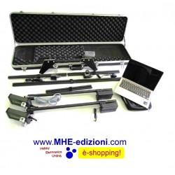
This Version of OERAD EasyRad GPR includes:
- 1 kit of use GPR aluminum, with electronic devices adjustable in height
- 2 Antennas small, value 500 Mhz, depth from 0 meters to about 6 meters
- 2 Antennas medium value 300 Mhz, depth from 6 meters to 12 meters around
- Kit of bolts, screws and screwdriver for assembly and disassembly components
- 1 Driver for hardware, software and scan data processing software
- 1 Installation and use Easyrad
- Stage 1 practical free software and hardware acquisition and use Easyrad
- Dual Battery GPR GPR / autonomy 10 hours
- Transport case insulated shockproof
- Extended warranty of five years to cover the electronic parts
- 1 Computer preconfigured by 11 "with Windows or Android Tablet choice
- 1 wireless device shielded (GPR for the computer, including one transmitter and one receiver)
EasyRad GPR is a portable multi-purpose scanning ground penetrating radar of sub-surface probing for the problems of engineering geology, hydrogeology, archeology, ecology, field engineering as well as for search and rescue operations.
Exclusive Functional Characteristics:
• easy handling during probing and profiling operations of objects;
• information display in a readily understandable format for a user;
• live video - indication of results of probing and profiling operations in real time on the screen;
• capability for further processing of the saved results of probing and profiling operations in a variety of graphic packages as well as in 2D, 3D and video formats;
• possibility of quick spreading of antenna mitter and receiving box at considerable distance for a detailed exploration of deep seated features;
• possibility of the sub-surface profiling of objects from the board of vehicles, air vehicles (Pro version), on ice and water;
• possibility to analyze electrical characteristics, humidity and velocity of radio-wave propagation in the soil layers;
• identification of physical characteristics of non-uniformities of subsurface structure of subsoil as well as the moisture distribution in depth;
• possibility of signals separation, reflected from the low-contrast layers (level of subsoil water, layer of liquid petroleum products, etc.) at depths up to 15 (30-50 Pro version) meters;
• use of complex radio physical and hydrogeological information in the form of models of physical processes in the process of interpretation of the results of probing and profiling operations.
Geotechnical Issues to Solve:
• Nondestructive diagnostic testing of the soil condition beneath the surface of urban areas, industrial sites and separate unique installations (evaluation of moisture of layers, detection and mapping of distribution of leakage water zones, assessment of flooding, detection of voids and the soil decompression).
• Assessment of the condition of the subsurface structure of subsoil of dams, embankments, coast defenses, quays (evaluation of the moisture level of the soil layers, the degree of decompression).
• Control over the condition of road surfaces, soil and fill under railway bed.
• Assessment and diagnostic testing of the subsurface structure and the soil condition of landslides, mapping of the areas of their distribution as well as evaluation of their sustainability.
• Mapping of the areas of distribution of liquid petroleum products (lenses) as a result of unauthorized leaks and accidents beneath the surface of industrial and technology-related areas.
• Mapping of underground communication facilities (cables, pipelines and other underground facilities).
• Identification of condition of foundations and building structure of existing installations.
• Detection of non-homogeneity of the subsurface structure of soil, associated with archeological artifacts.
• Area survey during field engineering and search and rescue operations.
Ground Penetrating Radar Operating Principle
The device refers to a class of single-pulse ground penetrating radars of subsurface probing (GPR) to a category of ultra wide-band technology (UWB) and is one of the instruments of probing the subsoil structure at a depth of several tens of meters in order to detect and identify the spatial boundaries of attitude of different kinds of subsurface non-homogeneities (objects, which have got different from the environment characteristics: dielectric constant and conductance, for example, of a humidity zone, soil softening zones, voids, embedment of more/less solid substance, etc.).
Ground penetrating radar operating principle is based on probing of physical medium with the electromagnetic impulses height of 1 (5-10 Pro version) kilovolt with a duration within the order of 2-8 nanoseconds and registration of height and time delay of return signals from the borders of the environment sectioning with different dielectric constant. GPR allows to probe the subsoil at a depth of 15 (30-50 Pro version) meters.
The probing signal induced by the antenna of GPR spreads under the surface of ground, dying out progressively as spreading, and, meeting the non-homogeneity, partially reflects in various directions, as well as in the direction of the receiving antenna. Level of incoming signals depends on the reflection coefficient of signals from a subsurface non-homogeneity. The reflection coefficient depends on how much the electrical parameters of non-homogeneities are different from the parameters of the environment. The more such difference is, the higher is the reflected signal. One piece of a signal goes further and reflects from another non-homogeneity and so on until the complete dying out of the signal.
EasyRad GPR can be packaged with different types of antennas to solve different tasks. The most simple in the low budget version are the dipole antennas.
As a radiating system for experts a specialized antenna is engineered (option, Pro version), which has a lower radiating level to the upper half-space and lowered lobed patterns along the ground surface.
The antenna is based on a magnetic slot antenna on the basis of open resonator system. Antenna directivity diagram of the GPR has a width not exceeding 25 degrees.
Use of such type of probing signal gave the opportunity with a relative ease to apply the methods which lead to a gain in the ration signal/ contaminating signal and in the long run to get considerably bigger depth of probing.
APPLICATIONS:
Engineering-geological problems with the possibility of measuring not only on the surfaces of soil, buildings, installations, but also on board of air vehicles, ice and water.
• Nondestructive diagnostic testing of the soil condition beneath the surface of urban areas, industrial sites and separate unique installations (evaluation of moisture of layers, detection and mapping of distribution of leakage water zones, assessment of flooding, detection of voids and the soil decompression).
• Assessment of the condition of the subsurface structure of subsoil of dams, embankments, coast defenses, quays (evaluation of the moisture level of the soil layers, the degree of decompression).
• Control over the condition of road surfaces, soil and fill under railway bed.
• Assessment and diagnostic testing of the subsurface structure and the soil condition of landslides, mapping of the areas of their distribution as well as evaluation of their sustainability.
• Mapping of contaminated soil, landfills of industrial and household wastes.
• Mapping of the areas of distribution of liquid petroleum products (lenses) as a result of unauthorized leaks and accidents beneath the surface of industrial and technology-related areas.
• Mapping of underground communication facilities (cables, pipelines and other underground facilities).
• Identification of condition of foundations and building structure of existing installations.
• Detection of non-homogeneity of the subsurface structure of soil, associated with archeological artifacts.
• Area survey during field engineering and search and rescue operations.
• Survey of water areas (identification of depth and profile of the bottom of rivers and lakes, thickness of the ice and snow, detection of submerged objects).
• Search and identification of any metal and non-metal purposes, voids.
• Delivery of the equipment complexes for subsurface probing: ground penetrating radars, magnetometers, gradiometers, anomaly detectors, electro/magnetic scanners, IR imagers, specialized metal detectors.
Areas of application.
1. Engineering.
Mapping and Localization of:
• gaps and defects in structure;
• thickness of the coating, foundation, etc.;
• valves, columns and other bearing structures;
• thinning, deformation and other types of damage of coating, foundation, etc.;
• built-in units components and systems in constructions and structures.
Nondestructive research, assessment and monitoring of coatings, platforms, foundations, slabs, retaining and supporting structures as well as other structures.
2. Communications.
Mapping and Localization of:
• buried and walled pipes, cables, channels, tunnels, etc.;
• underwater pipes, cables, tunnels, etc.;
• efflux in pipes (water, gas, etc.).
Nondestructive research, assessment and monitoring of all kinds of communication.
3. Transportation.
Mapping and Localization of:
• cracks, dip of earth masses, voids and other defects in the base and coating of roads, highways, railway tracks and other installations;
• cracks, dip of earth masses and other defects in tunnels and tunnel constructions;
• tinning, deformations, cracks, voids and other defects in bridges and bridge constructions.
Nondestructive research, assessment and monitoring of roads, highways, railway tracks, tunnels, bridges and other structures.
4. Environment.
Mapping and Localization of:
• leaks, spills and other pollutants spread;
• buried, concreted and underwater hazardous wastes;
• underground storage tanks of pollutants; protected natural sites.
Nondestructive research, assessment and monitoring of condition of polluted areas, groundwater, reservoirs, storage of hazardous wastes and protected natural sites.
5. Geotechnological.
Mapping of:
• bedrock;
• sediments;
• underwater sediments;
• soils;
• aquifers;
• bottom of lakes and rivers;
• karsts formations (cavities, etc.);
• gatherings of earth masses, landslides.
Research, assessment and monitoring of geological and hydrological conditions.
6. Mining.
Mapping and Localization of:
• coal layers;
• gold diggings;
• salt pans;
• deposits of bauxites;
• hazardous areas in open pit mines and mine galleries.
Research, assessment and monitoring of miming and hazardous areas.
7. Military. Search and Rescue.
Mapping and Localization of:
• cables, pipelines, tunnels, communication; caverns, caves, bunkers, etc.;
• anti-personnel and anti-tank mines;
• unexploded shell;
• defects in roads, highways, bridges, tunnels, bunkers, landfills, etc.;
• scarps and counterscarps.
8. Archeological.
Mapping and Localization of:
• cultural layers and archeological objects;
• graves, tombs, tunnels, walls, foundations, furnaces and other artifacts.
9. Judicial.
Mapping and Localization of:
• single and mass graves;
• buries, concreted or otherwise hidden weapons, ammunition supplies, hazar.
MHE Edizioni
Mobile: 392-92.07.751 - Segreteria: 085-44.83.165
info@mhe-edizioni.com
Metal Detector Division
Reviews
